Skip to content
FREE SHIPPING FOR ORDERS ABOVE $200
Skip to product information
1 of 4

1906 Los Angeles Map Poster - Panoramic City Plan with Streets and Rail Lines

$45.00
$45.00 $55.00
Sale Sold out

Lowest price in 30 days: $45.00 USD

Frame style: Unframed
Size: 91x61cm | 24x36in
  • Free Shipping - On All Orders Over $250!
Secure Payment
  • American Express
  • Apple Pay
  • Bancontact
  • BLIK
  • Google Pay
  • Maestro
  • Mastercard
  • MobilePay
  • PayPal
  • Shop Pay
  • Union Pay
  • Visa

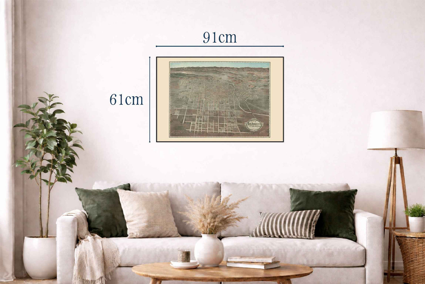
This bird’s-eye view map, titled “Map of Los Angeles and Suburbs,” was produced in 1906 by Lawson, H. R. and the Riley-Moore Co., based in Los Angeles. Published by A. Humitsch, the map was issued as a first edition during a period of significant growth for the city. Functioning as both a promotional and practical artifact, this map was distributed as a souvenir and commercial guide, particularly for the Holmes Book Co., one of California's most prominent antiquarian booksellers in the early twentieth century.

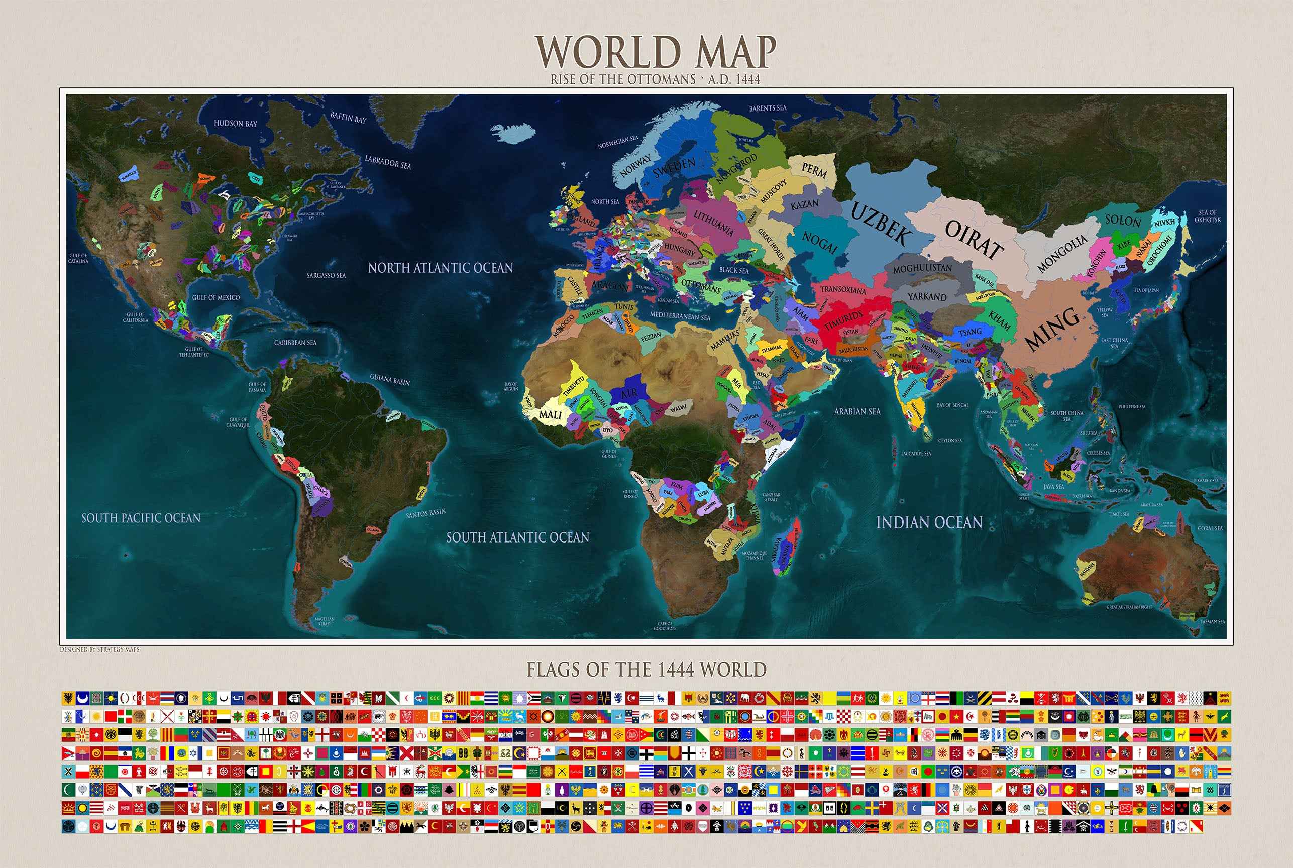
The map provides a panoramic vista of Los Angeles and its rapidly expanding suburban area in the years before World War I. It is organized with an elevated, oblique view that looks northeast across the Los Angeles basin toward a mountainous horizon. The dense city grid is depicted radiating outward from the urban center, with principal streets and car lines distinctly marked. The map’s borders are populated by an extensive alphanumeric index, referencing hundreds of individual locations, and the right margin includes a column of red-printed annotations that further clarify key sites and features.

This is a reproduction print of a historical map

Author:
Lawson, H. R.

Riley-Moore Co.

Date:
1906

Source: David Rumsey Map Collection, David Rumsey Map Center, Stanford Libraries

Everything is printed by ourselves in Poland.

We use a top quality Canon printer
Canon ImagePROGRAF PRO 2600 providing:

  • 2400 x 1200 dpi
  • 12-color printing system using Lucia-PRO II inks
  • High-precision printing with 5 pl droplet size per color
  • Print head with nozzle compensation function

The print is done on Cotton Canvas (
390 g/m²) prociding a vintage map feeling.

Currently we offer black hardboard frames with polystyrene plastic front protection.

Available in sizes:

  • 91x61cm | 24x36in
  • 70x50cm | 28x20in

We work with a range of trusted logistics providers to ensure you get the best balance of cost and delivery quality, including FedEx, UPS, and DPD. We currently ship to 32 countries worldwide, including 25 countries within the European Union, as well as the United Kingdom, Switzerland, Canada, Japan, Singapore, Hong Kong and the United States.

All orders include full tracking, so you can monitor your shipment every step of the way. We also offer free shipping on all orders with a cart value above $200.

If your postal code is not supported by our standard shipping options, please contact us at contact@strategymaps.co
and we will arrange a custom shipping solution tailored to your location.

We have a 30-day return policy, which means you have 30 days after receiving your item to request a return. To be eligible for a return, your item must be in the same condition that you received it, and in its original packaging. You’ll also need the receipt or proof of purchase.

When buying within the European Union have the right to cancel or return your order within 14 days, for any reason and without a justification.

Read more about return policy here.

View Product Details

From map lovers for map lovers

Get Your Hometown Blueprint Map - Modern City Street Wall Art